标签:
1、WorldWind如何确定与视点相关的地形数据的LOD层级与范围?
问题描述:WW中是如何判断LOD层次的呢,即在什么情况下获得哪一层级的数据?是否只通过相机视点的高度进行判断?
问题切入:要解决这个问题,我先说明一下WW的渲染机制,在渲染线程中,Render函数只负责渲染可渲染物体,而不负责视点的更新和Lod的判断。在m_World.Render(this.drawArgs)中可渲染的物体都是通过另一个更新线程WorkerThreadFunc来控制的,具体由m_World.Update(this.drawArgs)实现。因此要找到这个问题的答案需要从Update着手。重点注意m_World.Update(this.drawArgs)中的两段代码。如下所示:
可渲染物体的递归更新:
if (this.RenderableObjects != null)
            {
                this.RenderableObjects.Update(drawArgs);
            }
            if (this.m_WorldSurfaceRenderer != null)
            {
                this.m_WorldSurfaceRenderer.Update(drawArgs);
            }
            if (this.m_projectedVectorRenderer != null)
            {
                this.m_projectedVectorRenderer.Update(drawArgs);
            }
相机视点的高度更新:
if (this.TerrainAccessor != null)
            {
                if (drawArgs.WorldCamera.Altitude < 300000)
                {
                    if (System.DateTime.Now - this.lastElevationUpdate > TimeSpan.FromMilliseconds(500))
                    {
                        drawArgs.WorldCamera.TerrainElevation = (short)this.TerrainAccessor.GetElevationAt(drawArgs.WorldCamera.Latitude.Degrees, drawArgs.WorldCamera.Longitude.Degrees, 100.0 / drawArgs.WorldCamera.ViewRange.Degrees);
                        this.lastElevationUpdate = System.DateTime.Now;
                    }
                }
                else
                    drawArgs.WorldCamera.TerrainElevation = 0;
            }
            else
            {
                drawArgs.WorldCamera.TerrainElevation = 0;
            }
问题答案:搜索全局Update,重点关注SurfaceTile的Update和QuadTile的Update。
SurfaceTile的Update:
if(drawArgs.WorldCamera.TrueViewRange < Angle.FromDegrees(3.0f*tileSize) && MathEngine.SphericalDistance( Angle.FromDegrees(centerLatitude), Angle.FromDegrees(centerLongitude), drawArgs.WorldCamera.Latitude, drawArgs.WorldCamera.Longitude) < Angle.FromDegrees( 2.9f*tileSize )& drawArgs.WorldCamera.ViewFrustum.Intersects(m_BoundingBox))
                {
                    if(m_NorthWestChild == null || m_NorthEastChild == null || m_SouthWestChild == null || m_SouthEastChild == null)
                    {
                        ComputeChildrenTiles(drawArgs);
                    }
                    else
                    {
                        if(m_NorthEastChild != null)
                        {
                            m_NorthEastChild.Update(drawArgs);
                        }
                        if(m_NorthWestChild != null)
                        {
                            m_NorthWestChild.Update(drawArgs);
                        }
                        if(m_SouthEastChild != null)
                        {
                            m_SouthEastChild.Update(drawArgs);
                        }
                        if(m_SouthWestChild != null)
                        {
                            m_SouthWestChild.Update(drawArgs);
                        }
                    }
                }
                else
                {
                    if(m_NorthWestChild != null)
                    {
                        m_NorthWestChild.Dispose();
                        m_NorthWestChild = null;
                    }

                    if(m_NorthEastChild != null)
                    {
                        m_NorthEastChild.Dispose();
                        m_NorthEastChild = null;
                    }

                    if(m_SouthEastChild != null)
                    {
                        m_SouthEastChild.Dispose();
                        m_SouthEastChild = null;
                    }

                    if(m_SouthWestChild != null)
                    {
                        m_SouthWestChild.Dispose();
                        m_SouthWestChild = null;
                    }
                }
QuadTile的Update:
if (DrawArgs.Camera.ViewRange < Angle.FromDegrees(QuadTileSet.TileDrawDistance * tileSize)&& MathEngine.SphericalDistance(CenterLatitude, CenterLongitude,DrawArgs.Camera.Latitude, DrawArgs.Camera.Longitude) < Angle.FromDegrees(QuadTileSet.TileDrawSpread * tileSize)&& DrawArgs.Camera.ViewFrustum.Intersects(BoundingBox))
                    {
                        if (northEastChild == null || northWestChild == null || southEastChild == null || southWestChild == null)
                        {
                            ComputeChildren(drawArgs);
                        }

                        if (northEastChild != null)
                        {
                            northEastChild.Update(drawArgs);
                        }

                        if (northWestChild != null)
                        {
                            northWestChild.Update(drawArgs);
                        }

                        if (southEastChild != null)
                        {
                            southEastChild.Update(drawArgs);
                        }

                        if (southWestChild != null)
                        {
                            southWestChild.Update(drawArgs);
                        }
                    }
                    else
                    {
                        if (northWestChild != null)
                        {
                            northWestChild.Dispose();
                            northWestChild = null;
                        }

                        if (northEastChild != null)
                        {
                            northEastChild.Dispose();
                            northEastChild = null;
                        }

                        if (southEastChild != null)
                        {
                            southEastChild.Dispose();
                            southEastChild = null;
                        }

                        if (southWestChild != null)
                        {
                            southWestChild.Dispose();
                            southWestChild = null;
                        }
                    }
在这里我们看到判断Lod的级别主要有三个条件:
1、相机视角范围,视角范围越大,所包含的tileSize就越大;
2、相机与瓦片距离,距离越远,所包含的tileSize也就越大;
3、相机视锥与瓦片是否相交。
相对应我们可以把视角剔除方法理解成以下三步:
1、根据视角范围,画个大圈,把大圈里的大瓦片全加进来;
2、根据相机与瓦片的距离进行细化瓦片,如果太远的瓦片仍然保持很大,而近处的瓦片需要进一步更新,计算子瓦片;
3、每计算一个瓦片都需要判断它是否在视锥里,否则剔除身后看不到的瓦片。
在理解以上三个条件的前提下,需要理解的是视角、距离到底与tileSize有什么关系。对于不同级别影像或地形,ww中设置了相应的大小,根据一定的比例系数和经验参数寻找与距离和视角的关系。即通过调整参数 可控制在怎样的距离下可以看到怎样级别的地形或影像。例如在地形中设置为3.0、2.9等常数,在影像中设置为TileDrawDistance和TileDrawSpread等常数。只是反映了一定的经验参数而已。
2、WorldWind中对地块接边的处理是有裂缝的,采用裙摆设置的原理和方法实现是什么?
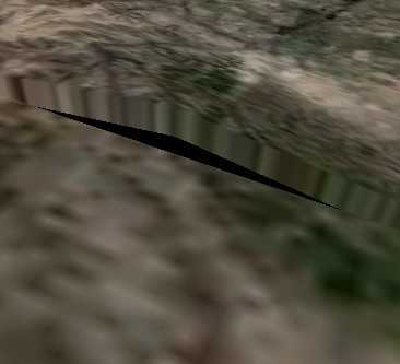
问题描述:对于不同级别的地形要进行接边是个很重要的问题,这个问题在我推荐的文献《全球多分辨率虚拟地形环境关键技术的研究》(作者杜莹2005博士)中有详细说明,而WW只是选择了最简单最原始的接地处理,也就是常说的裙摆处理。这种处理方法有很多的不利之处,但是实现方法简便,在此做简单说明。
问题切入:要想追踪这个问题,首先想到的是QuadTile的Update,而不从Render着手。Update就像在炒菜前把所有材料都准备的工作,如果没准备好就不能炒。在QuadTile的Update中,从CreateTileMesh切入,发现了CreateElevatedMesh和CreateFlatMesh的区别,显然裙摆是针对地形网格而做的处理在CreateElevatedMesh再深入到子函数,其中有一段很重要的说明:
/// <summary>
        /// Builds flat or terrain mesh for current tile//为当前瓦片创建平坦或高程格网
        /// </summary>
        public virtual void CreateTileMesh()
        {
            verticalExaggeration = World.Settings.VerticalExaggeration;
            m_CurrentOpacity = QuadTileSet.Opacity;
            renderStruts = QuadTileSet.RenderStruts;

            if (QuadTileSet.TerrainMapped && Math.Abs(verticalExaggeration) > 1e-3)
                CreateElevatedMesh();
            else
                CreateFlatMesh();
        }
在CreateElevatedMesh再深入到子函数,其中有一段很重要的说明:
/// <summary>
        /// Build the elevated terrain mesh
        /// </summary>
        protected virtual void CreateElevatedMesh()
        {
            isDownloadingTerrain = true;
            // Get height data with one extra sample around the tile
            double degreePerSample = LatitudeSpan / vertexCountElevated;
            TerrainTile tile = QuadTileSet.World.TerrainAccessor.GetElevationArray(North + degreePerSample, South - degreePerSample, West - degreePerSample, East + degreePerSample, vertexCountElevated + 3);
            float[,] heightData = tile.ElevationData;

            int vertexCountElevatedPlus3 = vertexCountElevated / 2 + 3;
            int totalVertexCount = vertexCountElevatedPlus3 * vertexCountElevatedPlus3;
            northWestVertices = new CustomVertex.PositionNormalTextured[totalVertexCount];
            southWestVertices = new CustomVertex.PositionNormalTextured[totalVertexCount];
            northEastVertices = new CustomVertex.PositionNormalTextured[totalVertexCount];
            southEastVertices = new CustomVertex.PositionNormalTextured[totalVertexCount];
            double layerRadius = (double)QuadTileSet.LayerRadius;

            // Calculate mesh base radius (bottom vertices)
            // Find minimum elevation to account for possible bathymetry
            float minimumElevation = float.MaxValue;
            float maximumElevation = float.MinValue;
            foreach (float height in heightData)
            {
                if (height < minimumElevation)
                    minimumElevation = height;
                if (height > maximumElevation)
                    maximumElevation = height;
            }
            minimumElevation *= verticalExaggeration;
            maximumElevation *= verticalExaggeration;

            if (minimumElevation > maximumElevation)
            {
                // Compensate for negative vertical exaggeration
                minimumElevation = maximumElevation;
                maximumElevation = minimumElevation;
            }

            double overlap = 500 * verticalExaggeration; // 500m high tiles

            // Radius of mesh bottom grid
            meshBaseRadius = layerRadius + minimumElevation - overlap;

            CreateElevatedMesh(ChildLocation.NorthWest, northWestVertices, meshBaseRadius, heightData);
            CreateElevatedMesh(ChildLocation.SouthWest, southWestVertices, meshBaseRadius, heightData);
            CreateElevatedMesh(ChildLocation.NorthEast, northEastVertices, meshBaseRadius, heightData);
            CreateElevatedMesh(ChildLocation.SouthEast, southEastVertices, meshBaseRadius, heightData);

            BoundingBox = new BoundingBox((float)South, (float)North, (float)West, (float)East, (float)layerRadius, (float)layerRadius + 10000 * this.verticalExaggeration);

            QuadTileSet.IsDownloadingElevation = false;

            // Build common set of indexes for the 4 child meshes
            int vertexCountElevatedPlus2 = vertexCountElevated / 2 + 2;
            vertexIndexes = new short[2 * vertexCountElevatedPlus2 * vertexCountElevatedPlus2 * 3];

            int elevated_idx = 0;
            for (int i = 0; i < vertexCountElevatedPlus2; i++)
            {
                for (int j = 0; j < vertexCountElevatedPlus2; j++)
                {
                    vertexIndexes[elevated_idx++] = (short)(i * vertexCountElevatedPlus3 + j);
                    vertexIndexes[elevated_idx++] = (short)((i + 1) * vertexCountElevatedPlus3 + j);
                    vertexIndexes[elevated_idx++] = (short)(i * vertexCountElevatedPlus3 + j + 1);

                    vertexIndexes[elevated_idx++] = (short)(i * vertexCountElevatedPlus3 + j + 1);
                    vertexIndexes[elevated_idx++] = (short)((i + 1) * vertexCountElevatedPlus3 + j);
                    vertexIndexes[elevated_idx++] = (short)((i + 1) * vertexCountElevatedPlus3 + j + 1);
                }
            }

            calculate_normals(ref northWestVertices, vertexIndexes);
            calculate_normals(ref southWestVertices, vertexIndexes);
            calculate_normals(ref northEastVertices, vertexIndexes);
            calculate_normals(ref southEastVertices, vertexIndexes);

            isDownloadingTerrain = false;
        }
这段注释的意思是说在:创建地形mesh的时候,在网格点的四周围多加一个点用于之后法向量的计算,而使用这种柱状顶点的效果将在法向量计算完后再折叠起来。这就是所谓的裙摆效果。在接下来的calculate_normals中,一眼就能看出折叠函数ProjectOnMeshBase,其具体实现如下:
// Project an elevated mesh point to the mesh base
        private Point3d ProjectOnMeshBase(Point3d p)
        {
            p = p + this.localOrigin;
            p = p.normalize();
            p = p * meshBaseRadius - this.localOrigin;
            return p;
        }
声明:本文的原创著作权利属于武汉大学GIS(地理信息系统)专业2009级本科毕业生杨建顺学长,本文的成文仅用于个人学习和研究,在此对原著者表示感谢。
WorldWind源码剖析系列:WorldWind如何确定与视点相关的地形数据的LOD层级与范围
标签:
原文地址:http://www.cnblogs.com/rainbow70626/p/5294095.html