标签:mat log html tde 移动 driving contex ble git
创建高德地图
功能真的很好很强大,有图有证据!

1.申请key值 去官网
2.https://webapi.amap.com/maps?v=1.4.11&key=e22196035aaa10db3b0b6eb1ab64619e
<script type="text/javascript" src="https://webapi.amap.com/maps?v=1.4.11&key=e22196035aaa10db3b0b6eb1ab64619e"></script>
3.有个div容器
4.创建地图 new AMap.Map(‘容器的名字‘);
初始化地图(默认设置)
    <div id="container"></div>
    <script type="text/javascript">
        new AMap.Map(‘container‘);
    </script>
初始化地图(简单自定义设置)
    var map = new AMap.Map(‘container‘,{
        zoom:16,
        center:[116.379391,39.861536],
    });
getZoom() 获取地图的级别
getCenter(); 获取地图的中心位置
Zoom 的数字越大 显示的越精细 越小显示的范围越大
setZoom 可以手动去设定地图级别
map.setZoom(15);
setCenter([]) 设置中心点,放入 坐标
map.setCenter([121.222,30]);
中心点和层级一起设定
map.setZoomAndCenter(12,[121.22,30])
获取级别和中心点
        console.log(map.getZoom());
        console.log(map.getCenter().toString());
on(‘moveend‘) //地图移动结束时
on(‘zoomend‘) //地图级别发生改变时
获取行政区
map.getCity(function(info){
info 当前中心点的行政区
});
        map.getCity(function(info){
            setCenterNode.innerHTML = info.province+‘,‘+info.district
        });
设置行政区
map.setCity(‘字符串‘) 想让地图到达该地区的中心点
    map.setCity(‘天津市‘);
获取地图的范围
    console.log(map.getBounds().northeast.toString());//右上角的坐标
    console.log(map.getBounds().southwest.toString());//左下角的坐标
通过事件来设定显示限制
        btn.onclick = function(){
            var bounds = map.getBounds();
            bounds.northeast.R = Number(xNode.value);
            bounds.southwest.R = Number(yNode.value);
            map.setLimitBounds(bounds);
        };
通过事件解除显示限制
        clear.onclick = function(){
            map.clearLimitBounds();
        };
设置地图的显示范围
    var myBounds = new AMap.Bounds([88.379391,20.861536],[117.379391,41.861536])
    map.setBounds(myBounds); //但是不是特别精准,会以它觉得最好的方式去显示
地图的平移
panBy(x,y) x代表向左平移多少像素 / y代表向上平移多少像素
panTo([x坐标,y坐标]) 地图会直接平移到这个位置
        <input type="" name="" id=‘xNode‘>
        <input type="" name="" id=‘yNode‘>
        btn.onclick =function(){
            map.panTo([xNode.value,yNode.value])
        };
获取鼠标的经纬度
longitude 经度 / latitude 纬度
        map.on(‘click‘,function(e){
            //xyNode.innerHTML = e.lnglat.lng + ‘,‘ + e.lnglat.lat;
            map.setCenter([e.lnglat.lng,e.lnglat.lat])
        });
设置地图鼠标的默认样式
setDefaultCursor(‘样式‘)
cursor : 里面所有的样式都可以
map.setDefaultCursor(‘-webkit-grabbing‘);
地图搜索
AMap.plugin(‘AMap.Autocomplete‘,function(){
    new AMap.Autocomplete().search(要搜索的内容,function(status,data){
        console.log(data 搜索出来的数据)
    })
})
案例:输入地址出现下拉列表,点击可切换地图
    <div id="container"></div>
    <div id=‘setCenterNode‘>
        <!-- 搜索框 -->
        <input type="" name="" id=‘searchText‘>
        <!-- 下拉列表内容显示位置 -->
        <ul id=‘node‘></ul>
    </div>
    ---------
    new AMap.Autocomplete({
        input:‘searchText‘
    });
加载插件的方式有两种
    <script type="text/javascript" src="https://webapi.amap.com/maps?v=1.4.11&key=e22196035aaa10db3b0b6eb1ab64619e&plugin=AMap.Autocomplete"></script>
    -------------
    new AMap.Autocomplete({
        input:‘searchText‘
    });
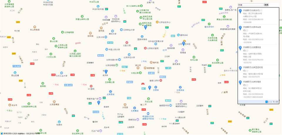
地图搜索与POI(兴趣点)结合1
    AMap.service([‘AMap.PlaceSearch‘],function(){
        new AMap.PlaceSearch({
            pageSize:5, //当页一共显示多少条
            pageIndex:1, //当前第几页
            city:‘010‘, //兴趣点的城市
            citylimit:true, //是否限制在设定的城内搜索
            map:map, //展示在哪个地图里
            panel:‘setCenterNode‘ //放在哪个元素下
        })
    })
地图搜索与POI(兴趣点)结合2
        var searchNode = new AMap.Autocomplete({
            input:‘searchIpt‘
        });
        var placeSearch = new AMap.PlaceSearch({
            map:map
        });
        AMap.event.addListener(searchNode,‘select‘,function(e){
            placeSearch.search(e.poi.name)
        });
地图搜索与POI(兴趣点)结合3--搜索周边
    new AMap.PlaceSearch({
        type:‘住宿‘, //搜索的结果的过滤 结果类型
        pageSize:5,
        pageIndex:1,
        city:‘010‘,
        citylimit:true,
        map:map, //展示在哪个地图里
        panel:‘setCenterNode‘ //放在哪个元素下
    }).searchNearBy(‘北京‘,[116.379391,39.861536],1000,function(){});
设置标记
    var marker = new AMap.Marker({
        icon:‘https://a.amap.com/jsapi_demos/static/demo-center/icons/poi-marker-default.png‘, //标记的图标
        position:[e.lnglat.lng,e.lnglat.lat], //标记的坐标
        offset:new AMap.Pixel(-25,-25) // 像素的偏差值
    });
    marker.setMap(map);
设置多个标记
        var marker = new AMap.Marker({
            icon:‘https://a.amap.com/jsapi_demos/static/demo-center/icons/poi-marker-default.png‘, //标记的图标
            position:[116.379391,39.861536], //标记的坐标
           // offset:new AMap.Pixel(-50,-500) // 像素的偏差值
        });
        var marker2 = new AMap.Marker({
            icon:‘https://a.amap.com/jsapi_demos/static/demo-center/icons/poi-marker-default.png‘, //标记的图标
            position:[116.378391,39.825536], //标记的坐标
           // offset:new AMap.Pixel(-50,-500) // 像素的偏差值
        });
        map.add([marker,marker2])
自定义标记图标
    var mk1 = new AMap.Icon({
        size:new AMap.Size(500,500), //图标大小
        image:‘./1.jpg‘, //图片地址
        imageSize:new AMap.Size(100,100) //最终在map里面显示的大小
    //  imageOffset:new AMap.Pixel(-50,-50) //裁剪 偏差值
    });
    var marker = new AMap.Marker({
        position:[116.379391,39.861536],
        icon:mk1
    });
    map.add([marker])
删除标记
    marker.setMap(null);
    map.remove([marker]);
缩放比例尺控件
    <script type="text/javascript" src="https://webapi.amap.com/maps?v=1.4.11&key=e22196035aaa10db3b0b6eb1ab64619e&plugin=AMap.Scale,AMap.ToolBar"></script>
    map.addControl(new AMap.scale());
    map.addControl(new AMap.ToolBar());
3d地图
    var map = new AMap.Map(‘container‘,{
        zoom:17,
        pitch:90,
        center:[116.379391,39.861536],
        viewMode:‘3D‘, //变成了3d 地图了
        buildingAnimation:true // 可以让显示的建筑物变成动画现实
    });
    map.addControl(new AMap.ControlBar({
        showZoomBar:true, // 显示 zoom条控件
       // showControlButton:true,// 可以取消 倾斜旋转角度的按钮
        position:{ //控件的定位
            right:‘50px‘,
            top:‘30px‘
        }
    }))
驾驶导航
    <script type="text/javascript" src="https://webapi.amap.com/maps?v=1.4.11&key=e22196035aaa10db3b0b6eb1ab64619e&plugin=AMap.Driving,AMap.Autocomplete"></script>
    new AMap.Driving({
        map:map,
        panel:‘panel‘
        }).search([
            {keyword:起点,city:‘北京‘},
            {keyword:终点,city:‘北京‘}
        ],function(status,data){
            console.log(data);
     })
通过鼠标点击获取起始点和终点,规划驾车路线
        var num = 0, arr = [];
        map.on(‘click‘,function(e){
            num++;
            if(num%2 == 1){
                arr = [e.lnglat.R,e.lnglat.P];
            }
            else{
                new AMap.Driving({
                    map:map,
                    panel:‘panel‘
                    }).search(new AMap.LngLat(arr[0],arr[1]),new AMap.LngLat(e.lnglat.R,e.lnglat.P),function(status,data){
                        console.log(data);
                })
            }
        });
通过经纬度 来进行导航
    new AMap.Driving({
        map:map,
        panel:‘panel‘
        }).search(new AMap.LngLat(startX,startY),new AMap.LngLat(endX,endY),function(status,data){
            console.log(data);
    })
步行路线的规划
    new AMap.Walking({
        map:map,
        panel:‘panel‘
        }).search([
            {keyword:起点,city:‘北京‘},
            {keyword:终点,city:‘北京‘}
        ],function(status,data){
            console.log(data);
    })
步行路线的坐标规划
    new AMap.Walking({
        map:map,
        panel:‘panel‘
        }).search([x,y],[x,y],function(status,data){
            console.log(data);
    })
货车路线规划(多点)-坐标
    <script type="text/javascript" src="https://webapi.amap.com/maps?v=1.4.11&key=e22196035aaa10db3b0b6eb1ab64619e&plugin=AMap.TruckDriving,AMap.Autocomplete"></script>
    new AMap.TruckDriving({
            map:map,
            panel:‘panel‘,
            city:‘beijing‘,//城市
            size:1 //大小
        }).search([{lnglat:[116.379391,39.861536]},{lnglat:[116.979391,39.161536]},{lnglat:[116.579391,40.861536]}],function(status,data){
            console.log(data);
    });
货车路线规划(多点)-位置
    new AMap.TruckDriving({
            map:map,
            panel:‘panel‘,
            city:‘beijing‘,//城市
            size:1 //大小
        }).search([{
            keyword:‘起点‘
        },
        {
            keyword:‘途径点‘
        }
        {
            keyword:‘途径点‘
        }
        {
            keyword:‘终点‘
        }],function(status,data){
            console.log(data);
    });
骑行路线规划
new AMap.Riding({
map:map,
panel:‘panel‘
}).search(new AMap.LngLat(startX,startY),new AMap.LngLat(endX,endY),function(status,data){
console.log(data);
})
    <div id="container"></div>
    <div id=‘panel‘></div>
    <div id=‘search‘>
        起点:<input type="" name="" id=‘startNode‘><br>
        终点:<input type="" name="" id=‘endNode‘><br>
        <button id=‘btn‘>开始导航</button>
    </div>
        var map = new AMap.Map(‘container‘,{
            zoom:11,
            center:[116.379391,39.861536],
        });
        new AMap.Autocomplete({
            input:‘startNode‘
        });
        new AMap.Autocomplete({
            input:‘endNode‘
        });
        btn.onclick = function(){
            new AMap.Riding({
                map:map,
                panel:‘panel‘
            }).search([
                {keyword:startNode.value,city:‘北京‘},
                {keyword:endNode.value,city:‘北京‘}
            ],function(status,data){
                console.log(data);
            })
        };
根据鼠标点击录入起始点和目标,规划骑行路线
        var num = 0, arr = [];
        map.on(‘click‘,function(e){
            num++;
            // 点击一次时将起始点计入数组
            if(num%2 == 1){
                arr = [e.lnglat.R,e.lnglat.P];
            }else{
                // 第二次点击时开始规划路线
                new AMap.Riding({
                    map:map,
                    panel:‘panel‘
                    }).search(new AMap.LngLat(arr[0],arr[1]),new AMap.LngLat(e.lnglat.R,e.lnglat.P),function(status,data){
                        console.log(data);
                })
            }
        });
地铁+公交的导航方式
   <script type="text/javascript" src="https://webapi.amap.com/maps?v=1.4.11&key=e22196035aaa10db3b0b6eb1ab64619e&plugin=AMap.Transfer,AMap.Autocomplete"></script>
    new AMap.Transfer({
        map:map,
        panel:‘panel‘
        }).search([
            {keyword:起始点,city:‘北京‘},
            {keyword:终点,city:‘北京‘}
            //只支持数组的前两个内容
        ],function(status,data){
            console.log(data);
    })
根据鼠标点击录入起始点和目标,规划公交路线
        var num = 0, arr = [];
        map.on(‘click‘,function(e){
            num++;
            if(num%2 == 1){
                arr = [e.lnglat.R,e.lnglat.P];
            }
            else{
                new AMap.Transfer({
                    map:map,
                    panel:‘panel‘,
                    city:‘北京‘
                    }).search(new AMap.LngLat(arr[0],arr[1]),new AMap.LngLat(e.lnglat.R,e.lnglat.P),function(status,data){
                        console.log(data);
                })
            }
        });
地图类型的切换
AMap.MapType 引入这个插件
    map.addControl(new AMap.MapType({
        defaultType:1,//0 默认 1代表的是卫星
        showRoad:true //显示路况
    }));
常用的插件 鹰眼插件 OverView
    <script type="text/javascript" src="https://webapi.amap.com/maps?v=1.4.11&key=e22196035aaa10db3b0b6eb1ab64619e&plugin=AMap.OverView"></script>
    map.addControl(new AMap.OverView());
控件的添加show()
控件的删除hide()
   <script type="text/javascript" src="https://webapi.amap.com/maps?v=1.4.11&key=e22196035aaa10db3b0b6eb1ab64619e&plugin=AMap.OverView,AMap.Scale,AMap.ToolBar"></script>
    var oV = new AMap.OverView({
        visible:true //默认显示和隐藏
    });
    var oS = new AMap.Scale();
    var oT = new AMap.ToolBar()
    map.addControl(oV);
    map.addControl(oS);
    map.addControl(oT);
    let yyNode = gjtNode = blcNode = true;
    // 鹰眼(点击对应的控制鹰眼按钮)
    yy.onclick = function(){
        if(yyNode == true){
            oV.hide();
        }
        else{
            oV.show();
        };
        yyNode = !yyNode
    };
    // 工具条
    gjt.onclick = function(){
        if(gjtNode == true){
            oT.hide();
        }
        else{
            oT.show();
        };

        gjtNode = !gjtNode
    };
    // 比例尺
    blc.onclick = function(){
        if(blcNode == true){
            oS.hide();
        }
        else{
            oS.show();
        };
        blcNode = !blcNode
    }
地图加载完成事件 complete
        map.on(‘complete‘,function(){
           var text = new AMap.Text({
             text:‘地图加载完成‘,
             draggable:true,
             position:[116.379391,39.861536]
           }).on(‘mousemove‘,function(){
            console.log(1)
           });
           text.setMap(map);

        });
        console.log(‘地图未加载‘);
地图显示等级改变事件
        map.on(‘zoomstart‘,function(){
            console.log(‘地图等级改变开始‘);
        });
        map.on(‘zoomend‘,function(){
            console.log(‘地图等级改变结束‘);
        });
中心点移动事件
        map.on(‘mapmove‘,function(){
            console.log(‘中心点移动中.‘);
        });
        map.on(‘movestart‘,function(){
            console.log(‘地图中心点开始移动‘);
        });
        map.on(‘moveend‘,function(){
            console.log(‘地图中心点移动结束‘);
        });
地图容器大小发生改变事件
    map.on(‘resize‘,function(){
        console.log(‘容器大小改变中‘);
    });
覆盖物与地图的交互
    //覆盖物
    var text = new AMap.Text({
        text:‘覆盖物事件‘,
        position:[116.379391,39.861536]
    });
    //鼠标移入覆盖物
    text.on(‘mouseover‘,function(){
        console.log(‘覆盖物移入‘);
    });
    //鼠标移出覆盖物
    text.on(‘mouseout‘,function(){
        console.log(‘覆盖物移出‘);
    });
    //鼠标在覆盖物上移动
    text.on(‘mousemove‘,function(){
        console.log(‘覆盖物上移动鼠标‘);
    });
插入圆形的矢量图
        var circle = new AMap.Circle({
            center:[116.379391,39.861536],
            radius:10
        });
        circle.setMap(map);
插入长方形的矢量图
        var rectangle = new AMap.Rectangle({
            bounds:new AMap.Bounds(new AMap.LngLat(116.379391,39.861536),new AMap.LngLat(116.379491,39.861636))
        });
        rectangle.setMap(map);
hide()隐藏
show()显示
    circle.hide();
    rectangle.show();
右键菜单事件
    //创建一个右键菜单
    var contextmenu = new AMap.ContextMenu();
    //右键的第一个菜单
    contextmenu.addItem(‘放大一级‘,function(){
        map.zoomIn();
    },0);
    //右键的第二个菜单
    contextmenu.addItem(‘缩小一级‘,function(){
        map.zoomOut();
    },1);
    //给地图绑定右键
    map.on(‘rightclick‘,function(e){
        //打开右键
        //map 在哪个地图里
        //参数2 - 位置
        contextmenu.open(map,e.lnglat);

        setTimeout(function(){
            contextmenu.close();
        },3000);
        // 关闭右键菜单
    });
DOM事件绑定
AMap.event.addDomListener (绑定的元素,绑定的事件名(click、mousedown),函数)
        var lis1 = AMap.event.addDomListener(button1,‘click‘,function(){
            map.zoomIn();
        });
DOM事件解除绑定
AMap.event.removeListener (要解除绑定函数名)
        AMap.event.addDomListener(button2,‘click‘,function(){
            AMap.event.removeListener(lis1);
        });
自定义事件 addListener/on/emit
       //变量记录点击几次
        var count = 0;
        //点击事件
        var _onClick = function(){
            //count事件:事件派发 也可以说是变量的改变
            map.emit(‘count‘,{count:count += 1});
        };
        //监听的变量发生改变时触发的函数
        var _onCount = function(){
            console.log(count);
        };
        //监听的变量发生改变时
        map.on(‘count‘,_onCount);
        AMap.event.addListener(map,‘click‘,_onClick);
标签:mat log html tde 移动 driving contex ble git
原文地址:https://www.cnblogs.com/chenyingying0/p/12155814.html