标签:android style blog class code c
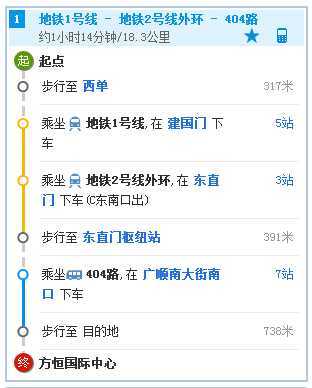
我们用高德地图SDK在进行路径规划后,除了将线路添加到地图时候,往往还需要获取线路的详细描述信息,比方说路线长度,所需时间、路线的每一段情况等,就如高度地图这样:

我们就简答实现下这个功能,首先进行公交线路查询(不清楚的同学可以看下demo),在查询结果中进行处理:
|
1
2
3
4
5
6
7
8
9
10
11
12
13
14
15
16
17
18
19
20
21
22
23
24
25
26
27
28
29
30
31
32
33
34
35
36
37
38
39
40
41
42
43
44
45
46
47
48
49
50
51
52
53
54
55
56
57
58
59
60
61
62
63
64
65
66
67
68
69
70
71
72
73
74
75
76
77
78 |
if
(busRouteResult != null
&& busRouteResult.getPaths() != null && busRouteResult.getPaths().size() > 0) { // 以推荐线路的第一条数据为例进行处理 BusPath busPath = busRouteResult.getPaths().get(0); // 分别获取公交线路距离,步行距离,整个线路距离 String routeInfo = "公交路线长度:"
+ busPath.getBusDistance() + " 步行 长度"
+ busPath.getWalkDistance() + " 线路长度:" + busPath.getDistance() + "\n"; List<BusStep> busSteps = busPath.getSteps(); // 获取每一段换乘所需的步行距离,起始终止站点,经过的站数(不包括起始和终点站),距离和所需时间 for
(BusStep busStep : busSteps) { if
(busStep.getWalk() != null) { RouteBusWalkItem walkPath = busStep.getWalk(); routeInfo = routeInfo + "需要步行大约" + Math.round(walkPath.getDuration() / 60) + "分钟,步行"
+ walkPath.getDistance() + "米\n"; } if
(busStep.getBusLine() != null) { RouteBusLineItem busLineItem = busStep.getBusLine(); routeInfo = routeInfo + "乘坐" + busLineItem.getBusLineName() + "需要大约" + Math.round(busLineItem.getDuration() / 60) + "分钟,大约" + busLineItem.getDistance() + "米,经过" + busLineItem.getPassStationNum() + "站,从" + busLineItem.getDepartureBusStation() .getBusStationName() + "上车,从" + busLineItem.getArrivalBusStation() .getBusStationName() + "下车\n"; } } mRouteInfoText.setText(routeInfo); |
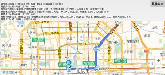
效果如下图所示:

同样的可以对步行、行车路线进行详细信息获取。具体代码(替换key)和apk见附件
高德地图AndroidSDK 路线规划详情获取,布布扣,bubuko.com
标签:android style blog class code c
原文地址:http://www.cnblogs.com/gisxs/p/3732077.html