标签:
1. 为Web Gis客户端开发的javascript 框架 百度文库中的教程:入门经典>
1) 初始化map:

 map = new OpenLayers.Map(mapContainerName, {
        controls: [new OpenLayers.Control.PanZoomBar({ zoomWorldIcon: true, position: new OpenLayers.Pixel(5, 22) }),
                       new OpenLayers.Control.Navigation(),
                       new OpenLayers.Control.LayerSwitcher(),
                       new OpenLayers.Control.ScaleLine({ maxWidth: 120, topOutUnits: "公里", topInUnits: "米", bottomOutUnits: "", bottomInUnits: "" }),
                       new OpenLayers.Control.MousePosition({ prefix: "经度:", separator: ",纬度:" }),
                       new OpenLayers.Control.KeyboardDefaults(),
                       new OpenLayers.Control.TouchNavigation({ dragPanOptions: { enableKinetic: true } })
        ],
        maxExtent: new OpenLayers.Bounds(-20037508.34, -20037508.34, 20037508.34, 20037508.34),
        maxResolution: 156543.0339,
        numZoomLevels: 10,
        units: ‘m‘,
        projection: "EPSG:900913",
        displayProjection: new OpenLayers.Projection("EPSG:4326")

}
2)瓦片行列式的计算
var x = Math.round((bounds.left - this.maxExtent.left) / (res * this.tileSize.w));
var y = Math.round((this.maxExtent.top - bounds.top) / (res * this.tileSize.h));
var z = this.map.getZoom();
2. 墨卡托投影(900913)是WGS84大地坐标系(经纬度)(4326)的投影(其中的一种投影方法),左右不变,上下拉长。
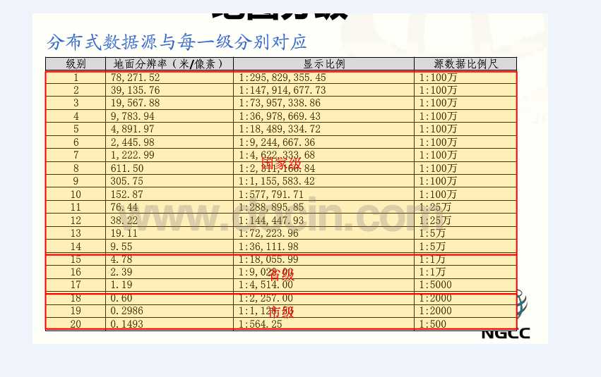
1) 地面分辨率Resolution: 一个像素表示多少米
2) 地图比例尺Scale:图上距离和实际距离的比例
maxResolution: 156543.0339, //显示比例
Bounds (-20037508.3427892, -20037508.3427892, 20037508.3427892, 20037508.3427892), numZoomLevels : 19, // 全球bounds范围

缩放级别
|
地图宽度、高度(像素) |
地面分辨率(米/像素) |
地图比例尺(以96dpi为例) |
|
|
0 |
256 |
156,543.0339 |
1 : 591,658,710.90 |
|
1 |
512 |
78,271.5170 |
1 : 295,829,355.45 |
|
2 |
1,024 |
39,135.7585 |
1 : 147,914,677.73 |
|
3 |
2,048 |
19,567.8792 |
1 : 73,957,338.86 |
|
4 |
4,096 |
9,783.9396 |
1 : 36,978,669.43 |
|
5 |
8,192 |
4,891.9698 |
1 : 18,489,334.72 |
|
6 |
16,384 |
2,445.9849 |
1 : 9,244,667.36 |
|
7 |
32,768 |
1,222.9925 |
1 : 4,622,333.68 |
|
8 |
65,536 |
611.4962 |
1 : 2,311,166.84 |
|
9 |
131,072 |
305.7481 |
1 : 1,155,583.42 |
|
10 |
262,144 |
152.8741 |
1 : 577,791.71 |
|
11 |
524,288 |
76.4370 |
1 : 288,895.85 |
|
12 |
1,048,576 |
38.2185 |
1 : 144,447.93 |
|
13 |
2,097,152 |
19.1093 |
1 : 72,223.96 |
|
14 |
4,194,304 |
9.5546 |
1 : 36,111.98 |
|
15 |
8,388,608 |
4.7773 |
1 : 18,055.99 |
|
16 |
16,777,216 |
2.3887 |
1 : 9,028.00 |
|
17 |
33,554,432 |
1.1943 |
1 : 4,514.00 |
|
18 |
67,108,864 |
0.5972 |
1 : 2,257.00 |
|
19 |
134,217,728 |
0.2986 |
1 : 1,128.50 |
|
20 |
268,435,456 |
0.1493 |
1 : 564.25 |
|
21 |
536,870,912 |
0.0746 |
1 : 282.12 |
|
22 |
1,073,741,824 |
0.0373 |
1 : 141.06 |
|
23 |
2,147,483,648 |
0.0187 |
1 : 70.53 |
1) google map 900913 地图分块算法,切片算法 》》》
2)墨卡托坐标和经纬度坐标互转 》》》
3)gis理论、墨卡托投影等 》》》
总数量:
http://www.map1000.com/jjj/mhQiantuMapHandler.ashx?searchType=2&f=getPoiCount&classId=8000100®ionCode=003910
GetPoiCountWithKey
getPoiCountWithClass
标签:
原文地址:http://www.cnblogs.com/camelroyu/p/5794252.html