标签:作用 for position single hid public base coding math

设置Object属性
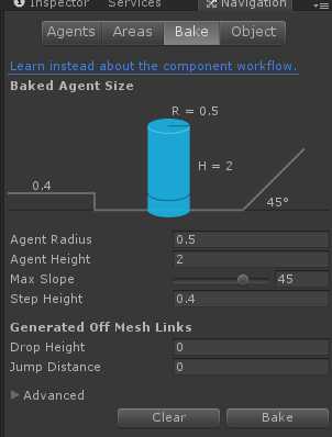
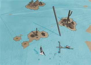
a)点击Bake烘焙出地图网络信息 b)烘焙后的网络信息图

 1 using System.IO;
 2 using UnityEditor;
 3 using UnityEngine.SceneManagement;
 4 using UnityEngine;
 5
 6 namespace AStar
 7 {
 8     //navmesh导出数据
 9     public class NavMeshExport : MonoBehaviour
10     {
11         [MenuItem("NavMesh/Export")]
12         static void Export()
13         {
14             Debug.Log("NavMesh Export Start");
15
16             UnityEngine.AI.NavMeshTriangulation navMeshTriangulation = UnityEngine.AI.NavMesh.CalculateTriangulation();
17
18             //文件路径
19             string path = Application.dataPath /*+ "/AStar/obj/"*/ + SceneManager.GetActiveScene().name + ".obj";
20
21             //新建文件
22             StreamWriter streamWriter = new StreamWriter(path);
23
24             //顶点
25             for (int i = 0; i < navMeshTriangulation.vertices.Length; i++)
26             {
27                 streamWriter.WriteLine("v " + navMeshTriangulation.vertices[i].x + " " + navMeshTriangulation.vertices[i].y + " " + navMeshTriangulation.vertices[i].z);
28             }
29
30             streamWriter.WriteLine("g pPlane1");
31
32             //索引
33             for (int i = 0; i < navMeshTriangulation.indices.Length;)
34             {
35                 streamWriter.WriteLine("f " + (navMeshTriangulation.indices[i] + 1) + " " + (navMeshTriangulation.indices[i + 1] + 1) + " " + (navMeshTriangulation.indices[i + 2] + 1));
36                 i = i + 3;
37             }
38
39             streamWriter.Flush();
40             streamWriter.Close();
41
42
43             AssetDatabase.Refresh();
44
45             Debug.Log("NavMesh Export Success");
46         }
47     }
48 }
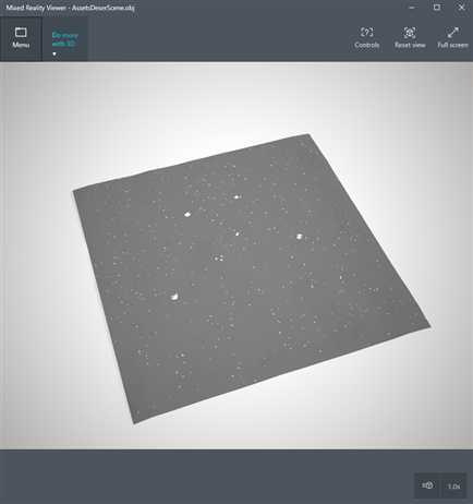
导出后的obj图
导出二维坐标代码:
  1 using UnityEngine;
  2 using System.Collections;
  3 using System.IO;
  4 using System.Text;
  5 using UnityEditor;
  6 using UnityEngine.SceneManagement;
  7 using UnityEngine;
  8
  9 public class NavArrayExport: MonoBehaviour
 10 {
 11     #region Public Attributes
 12     public Vector3 leftUpStart = Vector3.zero;
 13     public float accuracy = 1;
 14     public int height = 30;
 15     public int wide = 30;
 16     public float maxdistance = 0.2f;
 17     public float kmin = -10;
 18     public float kmax = 20;
 19     #endregion
 20
 21
 22     #region Public Methods
 23
 24     public void Exp()
 25     {
 26         exportPoint(leftUpStart, wide, height, accuracy);
 27     }
 28
 29     public float ConvertToNearestHalfNum(float num)
 30     {
 31         float numFloor = Mathf.Floor(num);
 32         float half = 0.5f;
 33         float d1 = num - numFloor;
 34         float d2 = Mathf.Abs(num - (numFloor + half));
 35         float d3 = numFloor + 1 - num;
 36         float d = Mathf.Min(d1, d2, d3);
 37         if(d == d1)
 38         {
 39             return numFloor;
 40         }
 41         else if(d == d2)
 42         {
 43             return numFloor + 0.5f;
 44         }
 45         else
 46         {
 47             return numFloor + 1f;
 48         }
 49     }
 50
 51     public void exportPoint(Vector3 startPos, int x, int y, float accuracy)
 52     {
 53         StringBuilder str = new StringBuilder();
 54         int[,] list = new int[x, y];
 55         str.Append("[MAP_DESC]\r\n");
 56         str.Append("startpos=").Append(startPos).Append("\r\n");
 57         str.Append("height=").Append(y).Append("\r\nwide=").Append(x).Append("\r\naccuracy=").Append(accuracy).Append("\r\n");
 58         for (int j = 0; j < y; ++j)
 59         {
 60             for (int i = 0; i < x; ++i)
 61             {
 62                 UnityEngine.AI.NavMeshHit hit;
 63                 for (float k = kmin; k < kmax; k+=0.5f)
 64                 {
 65                     Vector3 p = startPos + new Vector3(i * accuracy, k, -j * accuracy);
 66                     if (UnityEngine.AI.NavMesh.SamplePosition(p, out hit, maxdistance, UnityEngine.AI.NavMesh.AllAreas))
 67                     {
 68                         //Debug.DrawRay(new Vector3(ConvertToNearestHalfNum(hit.position.x), hit.position.y, ConvertToNearestHalfNum(hit.position.z)), Vector3.up, Color.green);
 69                         list[(int)(ConvertToNearestHalfNum(hit.position.x) * 2), (int)(ConvertToNearestHalfNum(hit.position.z) * 2)] = 1;
 70                         break;
 71                     }
 72                 }
 73             }
 74         }
 75         str.Append("map=");
 76         for (int j = 0; j < y; ++j)
 77         {
 78             str.Append("[");
 79             for (int i = 0; i < x; ++i)
 80             {
 81                 str.Append(Mathf.Abs(1 - list[i, j])).Append(",");
 82             }
 83             str.Append("],");
 84         }
 85         //文件路径
 86         string path = Application.dataPath + SceneManager.GetActiveScene().name + ".ini";
 87
 88         //新建文件
 89         StreamWriter streamWriter = new StreamWriter(path);
 90         streamWriter.Write(str.ToString());
 91         streamWriter.Flush();
 92         streamWriter.Close();
 93
 94
 95         AssetDatabase.Refresh();
 96     }
 97     #endregion
 98
 99 }
100
101 [CustomEditor(typeof(NavArrayExport))]
102 public class NavArrayExportHelper: Editor
103 {
104     public override void OnInspectorGUI()
105     {
106         base.OnInspectorGUI();
107         if (GUILayout.Button("Export"))
108         {
109             var exp = target as NavExport;
110             exp.Exp();
111         }
112     }
113 }
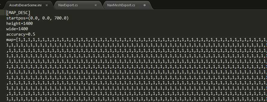 导出的二维坐标表
解决了客户端导出的地图信息后,服务端只需要通过获取客户端发送过来的start_pos和end_pos,并通过这两个点执行寻路逻辑,然后得到一串路径点,然后将这些路径点返回给客户端,客户端通过路径点执行对应人物的方向行走即可。不过要注意的是,这里客户端之所以是通过方向行走而不是直接走到那个路径点是因为我们是忽略了高度的因素)

  1 #!/bin/env python
  2 # -*- coding:utf8 -*-
  3 import os
  4 import ConfigParser
  5 import numpy
  6 from heapq import *
  7 from vector3 import Vector3
  8 from triangle import Triangle
  9 from math_tools import MathTools
 10 from common.singleton import Singleton
 11 from common.logger import Logger
 12 class Navmesh(Singleton):
 13     ‘‘‘
 14     服务端寻路组件
 15     ‘‘‘
 16     def __init__(self):
 17         self.vertices = []
 18         self.indices = []
 19         self.all_triangles = [] # 所有三角形
 20         self.all_center_o = [] # 所有三角形的重心
 21         self.point_2_triangles = {} # 点包含的三角形列表集合
 22
 23         # obj_file
 24         dir = os.path.dirname(os.path.realpath(__file__))
 25         #self.map_obj_file_name = ‘{}/{}‘.format(dir,‘test.obj‘)
 26         self.map_obj_file_name = ‘{}/{}‘.format(dir,‘AssetsDeserScene.obj‘)
 27
 28
 29     def load(self):
 30         with open(self.map_obj_file_name, ‘r+‘) as f:
 31             Logger().I(‘loading map data({})...‘.format(self.map_obj_file_name))
 32             lines = f.readlines()
 33             for line in lines:
 34                 for kv in [line.strip().split(‘ ‘)]:
 35                     if kv[0] == ‘v‘:
 36                         self.vertices.append(Vector3(float(kv[1]),float(kv[2]),float(kv[3])))
 37                     elif kv[0] == ‘f‘:
 38                         a = int(kv[1])-1
 39                         b = int(kv[2])-1
 40                         c = int(kv[3])-1
 41                         t = Triangle(self.vertices[a], self.vertices[b], self.vertices[c])
 42                         self.indices.append(Vector3(a,b,c))
 43                         self.all_triangles.append(t)
 44                         self.all_center_o.append(t.o)
 45
 46                         if t.a not in self.point_2_triangles:
 47                             self.point_2_triangles[t.a] = [t]
 48                         elif t not in self.point_2_triangles[t.a]:
 49                             self.point_2_triangles[t.a].append(t)
 50
 51                         if t.b not in self.point_2_triangles:
 52                             self.point_2_triangles[t.b] = [t]
 53                         elif t not in self.point_2_triangles[t.b]:
 54                             self.point_2_triangles[t.b].append(t)
 55
 56                         if t.c not in self.point_2_triangles:
 57                             self.point_2_triangles[t.c] = [t]
 58                         elif t not in self.point_2_triangles[t.c]:
 59                             self.point_2_triangles[t.c].append(t)
 60
 61         return True
 62
 63     def load_map_array(self):
 64         conf = ConfigParser.ConfigParser()
 65         conf.read(‘map/AssetsDeserScene.ini‘)
 66         map_data = conf.get(‘MAP_DESC‘,‘map‘)
 67         self.h = conf.getint(‘MAP_DESC‘,‘height‘)
 68         self.w = conf.getint(‘MAP_DESC‘,‘wide‘)
 69         self.accuracy = conf.getfloat(‘MAP_DESC‘,‘accuracy‘)
 70         self.nmap = numpy.array(eval(map_data))
 71
 72     def convert_pos_to_arr_idx(self, v_pos):
 73         #(0,0,700)->(0,0)
 74         #(100,0,700)->(0,199)
 75         #(100,0,600)->(199,199)
 76         x = (self.h - MathTools.convert_to_half_num(v_pos.z)) * self.accuracy - 1
 77         z = MathTools.convert_to_half_num(v_pos.x) * self.accuracy - 1
 78         return (int(x), int(z))
 79
 80     def convert_arr_idx_to_pos(self, idx):
 81         return Vector3((idx[1] + 1) / self.accuracy, 0, self.h - (idx[0] + 1)/self.accuracy)
 82
 83     def calulate_path_array(self, start_pos, end_pos):
 84         ‘‘‘
 85         通过二维数组的地图数据寻路
 86         @paramIn: [Vector3] start_pos
 87         @paramIn: [Vector3] end_pos
 88         ‘‘‘
 89         start = self.convert_pos_to_arr_idx(start_pos)
 90         end = self.convert_pos_to_arr_idx(end_pos)
 91         res = MathTools.astar(self.nmap, start, end)
 92
 93         paths = []
 94
 95         if res is False or len(res) == 0:
 96         # 找不到就直接走向end
 97             paths.append(end_pos)
 98             return paths
 99
100         # 将点路径转化为线段路径
101         res.reverse()
102         paths.append(self.convert_arr_idx_to_pos(res[0]))
103         if len(res) > 1:
104             for i in xrange(1,len(res)):
105                 if MathTools.check_points_in_line(start,res[i-1],res[i]):
106                     paths[-1] = self.convert_arr_idx_to_pos(res[i])
107                 else:
108                     # 斜率开始不一样,则添加最新的点
109                     paths.append(self.convert_arr_idx_to_pos(res[i]))
110                     start = res[i-1]
111         return paths
112
113
114
115
116     def calulate_path(self, start_pos, end_pos):
117         open_list = []
118         close_list = []
119         start_pos_triangle = Triangle(start_pos, start_pos, start_pos)
120         end_pos_triangle = Triangle(end_pos, end_pos, end_pos)
121
122         start_triangle, start_pos = MathTools.fix_border_point_if_needed(start_pos, self.all_triangles)
123         end_triangle, start_pos = MathTools.fix_border_point_if_needed(end_pos, self.all_triangles)
124         rv_path = {}
125         if start_triangle is None:
126             #Logger().W(‘start_pos is not in the navmesh‘)
127             return None
128         if end_triangle is None:
129             #Logger().W(‘end_pos is not in the navmesh‘)
130             return None
131
132         f = {}
133         g = {}
134         h = {}
135
136         open_list.append(start_pos_triangle)
137
138         while end_pos_triangle not in open_list and len(open_list) != 0:
139             # step 1. get the min triangle in open_list
140             t = open_list[0]
141             for i in xrange(0, len(open_list)):
142                 if open_list[i] not in f:
143                     f[open_list[i]] = 0
144                 if f[t] > f[open_list[i]]:
145                     t = open_list[i]
146
147             # step 2. remove the triangle from the open_list
148             open_list.remove(t)
149
150             # step 3. append the triangle to the close_list
151             close_list.append(t)
152
153             # step 4. explore
154
155             # step 4.1. get round triangles
156             current = t
157             if current == start_pos_triangle:
158                 current = start_triangle
159             round_triangles = []
160
161             if current.a in self.point_2_triangles:
162                 round_triangles = round_triangles + self.point_2_triangles[current.a]
163             if current.b in self.point_2_triangles:
164                 round_triangles = round_triangles + self.point_2_triangles[current.b]
165             if current.c in self.point_2_triangles:
166                 round_triangles = round_triangles + self.point_2_triangles[current.c]
167
168             # remove dulplicate triangles
169             round_triangles = sorted(set(round_triangles),key=round_triangles.index)
170             if end_triangle in round_triangles:
171                 round_triangles.append(end_pos_triangle)
172
173             # step 4.2
174             for i in xrange(0, len(round_triangles)):
175                 round_triangle = round_triangles[i]
176
177                 if round_triangle is t:
178                     continue
179
180                 if round_triangle in close_list:
181                     continue
182
183                 if round_triangle not in open_list:
184                     rv_path[round_triangle] = t
185                     if t not in g:
186                         g[t] = 0
187                     g[round_triangle] = g[t] + MathTools.distance(t.o,round_triangle.o)
188                     h[round_triangle] = MathTools.distance(round_triangle.o, end_pos)
189                     open_list.append(round_triangle)
190                 else:
191                     if round_triangle not in g:
192                         g[round_triangle] = 0
193                     if round_triangle not in h:
194                         h[round_triangle] = 0
195                     G = g[round_triangle]
196                     H = h[round_triangle]
197                     F = g[round_triangle] + MathTools.distance(round_triangle.o, t.o) + MathTools.distance(round_triangle.o, end_pos)
198                     if G + H > F:
199                         rv_path[round_triangle] = t
200                         g[round_triangle] = g[t] + MathTools.distance(t.o,round_triangle.o)
201                         h[round_triangle] = MathTools.distance(round_triangle.o, end_pos)
202                         open_list.remove(round_triangle)
203
204         path_list = []
205         t = end_pos_triangle
206         while t in rv_path and rv_path[t] is not None:
207             path_list.append(t.o)
208             t = rv_path[t]
209
210         path_list.reverse()
211
212         return path_list
213
214
215 # start_pos =Vector3(315.976135254,11.0661716461,360.217041016)
216 # end_pos = Vector3(315.970001221,11.86622715,350.790008545)
217 # nav = Navmesh()
218 # nav.load_map_array()
219 # print nav.calulate_path_array(start_pos,end_pos)
220
221 # start_pos = Vector3(-2.3, 0.3, -2.8)
222 # end_pos = Vector3(3.2, 0.0, -2.8)
223 # print nav.calulate_path(start_pos, end_pos)
224
225 # (-0.3, 0.1, -3.9)
226 # (1.7, 0.1, -4.2)
227 # (3.2, 0.1, -2.8)
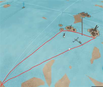
三角网络很大的情况
标签:作用 for position single hid public base coding math
原文地址:https://www.cnblogs.com/leothzhang/p/svr_nav.html