标签:修改 \n color unity read format http 参考 tps
需要将多幅TIF影像中的属性表导出后参与运算。
1. 打开 ArcMap 或者 ArcCatalog

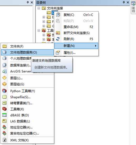
2. 在文件夹中新建文件地理数据库。

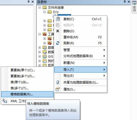
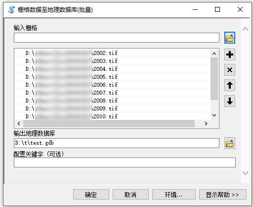
3. 导入栅格。


4. 打开Python窗口,修改代码,输入进行计算。
以下代码将各文件的属性表分别导出为.csv文件。合并为一个.csv 文件在第二段代码。
# coding:utf-8
#功能:批量导出栅格文件的属性表。
#使用步骤 1:在相应文件夹下新建“文件地理数据库”,并将需要导出属性表的栅格文件“导入”到该数据库中。
#使用步骤 2:更改第二行代码[ws = r‘D:\test\test1.gdb‘]为自己的文件存放地址和数据库名称,第三行同样的处理。
#使用步骤 3:复制代码在ArcGIS中运行即可。
import arcpy, os
ws = r‘D:\t\test.gdb‘
outPath = r‘D:\test‘
outExt = ".csv"
arcpy.env.workspace = ws
rasters = arcpy.ListRasters("*")
for raster in rasters:
     rasloc = ws + os.sep + raster
     fields = "*"
     try:
          lstFlds = arcpy.ListFields(rasloc)
          header = ‘‘
          for fld in lstFlds:
               header += ",{0}".format(fld.name)
               if len(lstFlds) != 0:
                    outCSV = outPath + os.sep + raster + outExt
                    f = open(outCSV,‘w‘)
                    header = header[1:] + ‘,RasterName\n‘
                    f.write(header)
                    with arcpy.da.SearchCursor(rasloc, fields) as cursor:
                         for row in cursor:
                              f.write(str(row).replace("(","").replace(")","") + "," + raster + ‘\n‘)
                    f.close()
     except Exception as e:
          print (e)
导出至同一个csv文件。
# coding:utf-8
#功能:批量导出栅格文件的属性表。
#使用步骤 1:在相应文件夹下新建“文件地理数据库”,并将需要导出属性表的栅格文件“导入”到该数据库中。
#使用步骤 2:更改第二行代码[ws = r‘D:\test\test.gdb‘]为自己的文件存放地址和数据库名称,第三行同样的处理。
#使用步骤 3:复制代码在ArcGIS中运行即可。
import arcpy, os
ws = r‘D:\test\test.gdb‘
outCSV = r‘D:\test\0.csv‘
arcpy.env.workspace = ws
rasters = arcpy.ListRasters("*")
for raster in rasters:
    rasloc = ws + os.sep + raster
    fields = "*"
    try:
        lstFlds = arcpy.ListFields(rasloc)
        header = ‘‘
        header += ",{0}".format(lstFlds[0].name)+",{0}".format(lstFlds[1].name)
        if len(lstFlds) != 0:
            f = open(outCSV,‘a‘)
            header =header[0:] + ‘,RasterName\n‘
            f.write(header)
            with arcpy.da.SearchCursor(rasloc, fields) as cursor:
                for row in cursor:
                    f.write(str(row).replace("(","").replace(")","") + "," + raster + ‘\n‘)
            f.close()
    except Exception as e:
        print (e)
del row
标签:修改 \n color unity read format http 参考 tps
原文地址:https://www.cnblogs.com/geozho/p/10167957.html