标签:
最近在做一个地图功能,其中有个功能就是根据当前经纬度获筛选附近的公司,第一次尝试,没有这方面的经验积累,网上找到了一种解决方案
PostgreSQL & PostGIS 这让一直受微软关照的我瞬间不知从何入手
后来找到了一种叫geohash 的解决方案,马上将数据库中的经纬度转换成geohash
附上geohash 算法 C#
 public static class Geohash
    {
        #region Direction enum

        public enum Direction
        {
            Top = 0,
            Right = 1,
            Bottom = 2,
            Left = 3
        }

        #endregion

        private const string Base32 = "0123456789bcdefghjkmnpqrstuvwxyz";
        private static readonly int[] Bits = new[] { 16, 8, 4, 2, 1 };

        private static readonly string[][] neighbors = {
                                                            new[]
                                                                {
                                                                    "p0r21436x8zb9dcf5h7kjnmqesgutwvy", // Top
                                                                    "bc01fg45238967deuvhjyznpkmstqrwx", // Right
                                                                    "14365h7k9dcfesgujnmqp0r2twvyx8zb", // Bottom
                                                                    "238967debc01fg45kmstqrwxuvhjyznp", // Left
                                                                }, new[]
                                                                       {
                                                                           "bc01fg45238967deuvhjyznpkmstqrwx", // Top
                                                                           "p0r21436x8zb9dcf5h7kjnmqesgutwvy", // Right
                                                                           "238967debc01fg45kmstqrwxuvhjyznp", // Bottom
                                                                           "14365h7k9dcfesgujnmqp0r2twvyx8zb", // Left
                                                                       }
                                                        };

        private static readonly string[][] Borders = {
                                                          new[] {"prxz", "bcfguvyz", "028b", "0145hjnp"},
                                                          new[] {"bcfguvyz", "prxz", "0145hjnp", "028b"}
                                                      };

        public static String CalculateAdjacent(String hash, Direction direction)
        {
            hash = hash.ToLower();

            char lastChr = hash[hash.Length - 1];
            int type = hash.Length % 2;
            var dir = (int)direction;
            string nHash = hash.Substring(0, hash.Length - 1);

            if (Borders[type][dir].IndexOf(lastChr) != -1)
            {
                nHash = CalculateAdjacent(nHash, (Direction)dir);
            }
            return nHash + Base32[neighbors[type][dir].IndexOf(lastChr)];
        }

        public static List<string> Neighbors(String hash)
        {
            List<string> result = new List<string>();
            result.Add(CalculateAdjacent(hash, Direction.Top));
            result.Add(CalculateAdjacent(hash, Direction.Bottom));
            result.Add(CalculateAdjacent(hash, Direction.Right));
            result.Add(CalculateAdjacent(hash, Direction.Left));
            result.Add(CalculateAdjacent(result[3], Direction.Top));
            result.Add(CalculateAdjacent(result[2], Direction.Top));
            result.Add(CalculateAdjacent(result[2], Direction.Bottom));
            result.Add(CalculateAdjacent(result[3], Direction.Bottom));
            return result;
        }

        public static void RefineInterval(ref double[] interval, int cd, int mask)
        {
            if ((cd & mask) != 0)
            {
                interval[0] = (interval[0] + interval[1]) / 2;
            }
            else
            {
                interval[1] = (interval[0] + interval[1]) / 2;
            }
        }

        public static double[] Decode(String geohash)
        {
            bool even = true;
            double[] lat = { -90.0, 90.0 };
            double[] lon = { -180.0, 180.0 };

            foreach (char c in geohash)
            {
                int cd = Base32.IndexOf(c);
                for (int j = 0; j < 5; j++)
                {
                    int mask = Bits[j];
                    if (even)
                    {
                        RefineInterval(ref lon, cd, mask);
                    }
                    else
                    {
                        RefineInterval(ref lat, cd, mask);
                    }
                    even = !even;
                }
            }

            return new[] { (lat[0] + lat[1]) / 2, (lon[0] + lon[1]) / 2 };
        }

        public static String Encode(double latitude, double longitude, int precision = 12)
        {
            bool even = true;
            int bit = 0;
            int ch = 0;
            string geohash = "";

            double[] lat = { -90.0, 90.0 };
            double[] lon = { -180.0, 180.0 };

            if (precision < 1 || precision > 20) precision = 12;

            while (geohash.Length < precision)
            {
                double mid;

                if (even)
                {
                    mid = (lon[0] + lon[1]) / 2;
                    if (longitude > mid)
                    {
                        ch |= Bits[bit];
                        lon[0] = mid;
                    }
                    else
                        lon[1] = mid;
                }
                else
                {
                    mid = (lat[0] + lat[1]) / 2;
                    if (latitude > mid)
                    {
                        ch |= Bits[bit];
                        lat[0] = mid;
                    }
                    else
                        lat[1] = mid;
                }

                even = !even;
                if (bit < 4)
                    bit++;
                else
                {
                    geohash += Base32[ch];
                    bit = 0;
                    ch = 0;
                }
            }
            return geohash;
        }
    }
PHP:
<?php

class Geohash {

    private $bitss = array(16, 8, 4, 2, 1);
    private $neighbors = array();
    private $borders = array();

    private $coding = "0123456789bcdefghjkmnpqrstuvwxyz";
    private $codingMap = array();

    public function __construct() {

        $this->neighbors[‘right‘][‘even‘] = ‘bc01fg45238967deuvhjyznpkmstqrwx‘;
        $this->neighbors[‘left‘][‘even‘] = ‘238967debc01fg45kmstqrwxuvhjyznp‘;
        $this->neighbors[‘top‘][‘even‘] = ‘p0r21436x8zb9dcf5h7kjnmqesgutwvy‘;
        $this->neighbors[‘bottom‘][‘even‘] = ‘14365h7k9dcfesgujnmqp0r2twvyx8zb‘;

        $this->borders[‘right‘][‘even‘] = ‘bcfguvyz‘;
        $this->borders[‘left‘][‘even‘] = ‘0145hjnp‘;
        $this->borders[‘top‘][‘even‘] = ‘prxz‘;
        $this->borders[‘bottom‘][‘even‘] = ‘028b‘;

        $this->neighbors[‘bottom‘][‘odd‘] = $this->neighbors[‘left‘][‘even‘];
        $this->neighbors[‘top‘][‘odd‘] = $this->neighbors[‘right‘][‘even‘];
        $this->neighbors[‘left‘][‘odd‘] = $this->neighbors[‘bottom‘][‘even‘];
        $this->neighbors[‘right‘][‘odd‘] = $this->neighbors[‘top‘][‘even‘];

        $this->borders[‘bottom‘][‘odd‘] = $this->borders[‘left‘][‘even‘];
        $this->borders[‘top‘][‘odd‘] = $this->borders[‘right‘][‘even‘];
        $this->borders[‘left‘][‘odd‘] = $this->borders[‘bottom‘][‘even‘];
        $this->borders[‘right‘][‘odd‘] = $this->borders[‘top‘][‘even‘];

        for($i=0; $i<32; $i++) {

            $this->codingMap[substr($this->coding, $i, 1)] = str_pad(decbin($i), 5, "0", STR_PAD_LEFT);
        }

    }

    public function decode($hash) {

        $binary = "";
        $hl = strlen($hash);
        for ($i=0; $i<$hl; $i++) {

            $binary .= $this->codingMap[substr($hash, $i, 1)];
        }

        $bl = strlen($binary);
        $blat = "";
        $blong = "";
        for ($i=0; $i<$bl; $i++) {

            if ($i%2)
                $blat=$blat.substr($binary, $i, 1);
            else
                $blong=$blong.substr($binary, $i, 1);

        }

        $lat = $this->binDecode($blat, -90, 90);
        $long = $this->binDecode($blong, -180, 180);

        $latErr = $this->calcError(strlen($blat), -90, 90);
        $longErr = $this->calcError(strlen($blong), -180, 180);

        $latPlaces = max(1, -round(log10($latErr))) - 1;
        $longPlaces = max(1, -round(log10($longErr))) - 1;

        $lat = round($lat, $latPlaces);
        $long = round($long, $longPlaces);

        return array($lat, $long);
    }


    private function calculateAdjacent($srcHash, $dir) {

        $srcHash = strtolower($srcHash);
        $lastChr = $srcHash[strlen($srcHash) - 1];
        $type = (strlen($srcHash) % 2) ? ‘odd‘ : ‘even‘;
        $base = substr($srcHash, 0, strlen($srcHash) - 1);

        if (strpos($this->borders[$dir][$type], $lastChr) !== false) {

            $base = $this->calculateAdjacent($base, $dir);
        }

        return $base . $this->coding[strpos($this->neighbors[$dir][$type], $lastChr)];
    }


    public function neighbors($srcHash) {

        //$geohashPrefix = substr($srcHash, 0, strlen($srcHash) - 1);

         $neighbors[‘top‘] = $this->calculateAdjacent($srcHash, ‘top‘);
         $neighbors[‘bottom‘] = $this->calculateAdjacent($srcHash, ‘bottom‘);
         $neighbors[‘right‘] = $this->calculateAdjacent($srcHash, ‘right‘);
         $neighbors[‘left‘] = $this->calculateAdjacent($srcHash, ‘left‘);

         $neighbors[‘topleft‘] = $this->calculateAdjacent($neighbors[‘left‘], ‘top‘);
         $neighbors[‘topright‘] = $this->calculateAdjacent($neighbors[‘right‘], ‘top‘);
         $neighbors[‘bottomright‘] = $this->calculateAdjacent($neighbors[‘right‘], ‘bottom‘);
         $neighbors[‘bottomleft‘] = $this->calculateAdjacent($neighbors[‘left‘], ‘bottom‘);

        return $neighbors;
    }


    public function encode($lat, $long) {

        $plat = $this->precision($lat);
        $latbits = 1;
        $err = 45;
        while($err > $plat) {

            $latbits++;
            $err /= 2;
        }

        $plong = $this->precision($long);
        $longbits = 1;
        $err = 90;
        while($err > $plong) {

            $longbits++;
            $err /= 2;
        }

        $bits = max($latbits, $longbits);

        $longbits = $bits;
        $latbits = $bits;
        $addlong = 1;
        while (($longbits + $latbits) % 5 != 0) {

            $longbits += $addlong;
            $latbits += !$addlong;
            $addlong = !$addlong;
        }


        $blat = $this->binEncode($lat, -90, 90, $latbits);
        $blong = $this->binEncode($long, -180, 180, $longbits);

        $binary = "";
        $uselong = 1;
        while (strlen($blat) + strlen($blong)) {

            if ($uselong) {

                $binary = $binary.substr($blong, 0, 1);
                $blong = substr($blong, 1);

            } else {

                $binary = $binary.substr($blat, 0, 1);
                $blat = substr($blat, 1);
            }

            $uselong = !$uselong;
        }

        $hash = "";
        for ($i=0; $i<strlen($binary); $i+=5) {

            $n = bindec(substr($binary, $i, 5));
            $hash = $hash.$this->coding[$n];
        }

        return $hash;
    }

    private function calcError($bits, $min, $max) {

        $err = ($max - $min) / 2;
        while ($bits--)
            $err /= 2;
        return $err;
    }

    private function precision($number) {

        $precision = 0;
        $pt = strpos($number,‘.‘);
        if ($pt !== false) {

            $precision = -(strlen($number) - $pt - 1);
        }

        return pow(10, $precision) / 2;
    }


    private function binEncode($number, $min, $max, $bitcount) {

        if ($bitcount == 0)
            return "";

        $mid = ($min + $max) / 2;
        if ($number > $mid)
            return "1" . $this->binEncode($number, $mid, $max, $bitcount - 1);
        else
            return "0" . $this->binEncode($number, $min, $mid, $bitcount - 1);
    }


    private function binDecode($binary, $min, $max) {

        $mid = ($min + $max) / 2;

        if (strlen($binary) == 0)
            return $mid;

        $bit = substr($binary, 0, 1);
        $binary = substr($binary, 1);

        if ($bit == 1)
            return $this->binDecode($binary, $mid, $max);
        else
            return $this->binDecode($binary, $min, $mid);
    }
}
demo
$length = 6;

$geohash = new Geohash();

$hash = substr($geohash->encode(‘39.981998‘,‘116.306785‘), 0, $length);

$box = $geohash->neighbors($hash);

$box[] = $hash;


$in_str = "‘".implode("‘,‘", $box)."‘";
echo $hash.‘<br/>‘;
echo $in_str;
这样就会生成包含自己的九宫格的范围区间
原理图
但是生成9个geohash 去in感觉性能太差了,然后不好限定范围,所以弃用了这个方案,选了另一个方案,根据中心点坐标算出需要范围的四个经纬度数据
原理图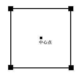
理论上一定范围是要基于圆形的,
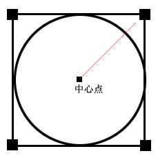 范围是个内切圆,这样圆心到四个角的范围就超出了指定范围,但是地图上显示的应该是方形的,所以我觉得应该也不用太纠结这点问题,现在附上源代码
C#
  1 public class Location
  2     {
  3         public double Latitude { get; set; }
  4         public double Longitude { get; set; }
  5         public Location(double lat,double lng)
  6         {
  7             Latitude = lat;
  8             Longitude = lng;
  9         }
 10     }
 11
 12 public class CoordDispose
 13     {
 14         /** 地球半径 */
 15         private static double EARTH_RADIUS = 6378137.0;
 16         /** 范围距离 */
 17         private double distance;
 18         /** 左上角 */
 19         private Location left_top = null;
 20         /** 右上角 */
 21         private Location right_top = null;
 22         /** 左下角 */
 23         private Location left_bottom = null;
 24         /** 右下角 */
 25         private Location right_bottom = null;
 26
 27         private CoordDispose(double distance)
 28         {
 29             this.distance = distance;
 30         }
 31
 32         private static double degrees(double d)
 33         {
 34             return d * (180 / Math.PI);
 35         }
 36
 37         private void getRectangle(double lat, double lng)
 38         {
 39
 40             // float dlng = 2 * asin(sin(distance / (2 * EARTH_RADIUS)) / cos(lat));
 41             // float dlng = degrees(dlng) // 弧度转换成角度
 42             double dlng = 2 * Math.Asin(Math.Sin(distance / (2 * EARTH_RADIUS)) / Math.Cos(radians(lat)));
 43             dlng = degrees(dlng);
 44
 45             // dlat = distance / EARTH_RADIUS
 46             // dlng = degrees(dlat) # 弧度转换成角度
 47             double dlat = distance / EARTH_RADIUS;
 48             dlat = degrees(dlat); // # 弧度转换成角度
 49
 50             // left-top : (lat + dlat, lng - dlng)
 51             // right-top : (lat + dlat, lng + dlng)
 52             // left-bottom : (lat - dlat, lng - dlng)
 53             // right-bottom: (lat - dlat, lng + dlng)
 54             left_top = new Location(lat + dlat, lng - dlng);
 55             right_top = new Location(lat + dlat, lng + dlng);
 56             left_bottom = new Location(lat - dlat, lng - dlng);
 57             right_bottom = new Location(lat - dlat, lng + dlng);
 58
 59         }
 60
 61         /// <summary>
 62         /// 计算两个经纬度之间的直接距离
 63         /// </summary>
 64         public static double GetDistance(Location lt1, Location lt2)
 65         {
 66             double radLat1 = radians(lt1.Longitude);
 67             double radLat2 = radians(lt2.Longitude);
 68             double a = radLat1 - radLat2;
 69             double b = radians(lt1.Latitude) - radians(lt2.Latitude);
 70             double s = 2 * Math.Asin(Math.Sqrt(Math.Pow(Math.Sin(a / 2), 2) + Math.Cos(radLat1) * Math.Cos(radLat2) * Math.Pow(Math.Sin(b / 2), 2)));
 71             s = s * EARTH_RADIUS;
 72             s = Math.Round(s * 10000) / 10000;
 73             return s;
 74         }
 75         /// <summary>
 76         /// 计算两个经纬度之间的直接距离(google 算法)
 77         /// </summary>
 78         public static double GetDistanceGoogle(Location lt1, Location lt2)
 79         {
 80             double radLat1 = radians(lt1.Longitude);
 81             double radLng1 = radians(lt1.Latitude);
 82             double radLat2 = radians(lt2.Longitude);
 83             double radLng2 = radians(lt2.Latitude);
 84             double s = Math.Acos(Math.Cos(radLat1) * Math.Cos(radLat2) * Math.Cos(radLng1 - radLng2) + Math.Sin(radLat1) * Math.Sin(radLat2));
 85             s = s * EARTH_RADIUS;
 86             s = Math.Round(s * 10000) / 10000;
 87             return s;
 88         }
 89
 90         public static double hav(double theta)
 91         {
 92             double s = Math.Sin(theta / 2);
 93             return s * s;
 94         }
 95
 96         private static double radians(double d)
 97         {
 98             return d * Math.PI / 180.0;
 99         }
100
101         public static double getDistance(double lat0, double lng0, double lat1,
102                 double lng1)
103         {
104             // from math import sin, asin, cos, radians, fabs, sqrt
105
106             // def hav(theta):
107             // s = sin(theta / 2)
108             // return s * s
109
110             // def get_distance_hav(lat0, lng0, lat1, lng1):
111             // "用haversine公式计算球面两点间的距离。"
112             // # 经纬度转换成弧度
113             // lat0 = radians(lat0)
114             // lat1 = radians(lat1)
115             // lng0 = radians(lng0)
116             // lng1 = radians(lng1)
117
118             // dlng = fabs(lng0 - lng1)
119             // dlat = fabs(lat0 - lat1)
120             // h = hav(dlat) + cos(lat0) * cos(lat1) * hav(dlng)
121             // distance = 2 * EARTH_RADIUS * asin(sqrt(h))
122
123             // return distance
124
125             lat0 = radians(lat0);
126             lat1 = radians(lat1);
127             lng0 = radians(lng0);
128             lng1 = radians(lng1);
129
130             double dlng = Math.Abs(lng0 - lng1);
131             double dlat = Math.Abs(lat0 - lat1);
132             double h = hav(dlat) + Math.Cos(lat0) * Math.Cos(lat1) * hav(dlng);
133             double distance = 2 * EARTH_RADIUS * Math.Asin(Math.Sqrt(h));
134
135             return distance;
136         }
137
138         public static Location[] getDegreeCoordinates(double lat, double lng,
139                 double distance)
140         {
141             CoordDispose llu = new CoordDispose(distance);
142             llu.getRectangle(lat, lng);
143             Location[] locations = new Location[4];
144             locations[0] = llu.left_top;
145             locations[1] = llu.right_top;
146             locations[2] = llu.left_bottom;
147             locations[3] = llu.right_bottom;
148             return locations;
149         }
150     }
PHP:
<?php

    class Location
    {
        public $Latitude;
        public $Longitude;
        public function __construct($lat,$lng) {
            $this->Latitude = $lat;
            $this->Longitude = $lng;
        }

        public function __tostring()
        {
            return $this->Longitude.‘,‘.$this->Latitude;
        }
    }

    class CoordDispose
    {
        //地球半径(米)
        private static $EARTH_RADIUS = 6378137.0;
        //范围距离
        private $distance;
        //左上角
        private $left_top;
        //右上角
        private $right_top;
        //左下角
        private $left_bottom;
        //右下角
        private $right_bottom;

        private function __construct($dist) {
            $this->distance = $dist;
        }

        public function getRectangle($lat,$lng){
            $dlng = 2 * asin(sin($this->distance / (2 * self::$EARTH_RADIUS)) / cos(self::radians($lat)));
            $dlng = self::degrees($dlng);
            $dlat = $this->distance / self::$EARTH_RADIUS;
            $dlat = self::degrees($dlat); // # 弧度转换成角度
            $this->left_top = new Location($lat + $dlat, $lng - $dlng);
            $this->right_top = new Location($lat + $dlat, $lng + $dlng);
            $this->left_bottom = new Location($lat - $dlat, $lng - $dlng);
            $this->right_bottom = new Location($lat - $dlat, $lng + $dlng);
        }

        public static function hav($theta){
            $s = sin($theta / 2);
            return $s * $s;
        }

        //角度数转换为弧度公式
        private static function radians($d){
            $pi = pi();
            return $d * $pi / 180.0;
        }
        //弧度转换为角度数公式
        private static function degrees($d){
            $pi = pi();
            return $d * (180.0 / $pi);
        }

        //计算两个经纬度之间的直接距离
        public static function getDistance($lt1,$lt2){
            $radLat1 = self::radians($lt1->Longitude);
            $radLat2 = self::radians($lt2->Longitude);
            $a = $radLat1 - $radLat2;
            $b = self::radians($lt1->Lat) - self::radians($lt2->Lat);
            $s = 2 * asin(sqrt(pow(Sin($a / 2), 2) + cos($radLat1) * cos($radLat2) * pow(sin($b / 2), 2)));
            $s = $s * self::$EARTH_RADIUS;
            $s = round($s * 10000) / 10000;
            return $s;
        }

        //计算两个经纬度之间的直接距离(google 算法)
        public static function getDistanceGoogle($lt1,$lt2){
            $radLat1 = self::radians($lt1->Longitude);
            $radLng1 = self::radians($lt1->Lat);
            $radLat2 = self::radians($lt2->Longitude);
            $radLng2 = self::radians($lt2->Lat);
            $s = acos(cos($radLat1) * cos($radLat2) * cos($radLng1 - $radLng2) + sin($radLat1) * sin($radLat2));
            $s = $s * self::$EARTH_RADIUS;
            $s = round($s * 10000) / 10000;
            return $s;
        }

        //以一个经纬度为中心计算出四个顶点
        //$lt1 中心点坐标
        //$distance 距离
        public static function getDegreeCoordinates($lt1,$distance){
            $llu = new self($distance);
            $llu->getRectangle($lt1->Latitude,$lt1->Longitude);
            $ret = array();
            $ret[] = $llu->left_top;
            $ret[] = $llu->right_top;
            $ret[] = $llu->left_bottom;
            $ret[] = $llu->right_bottom;
            return $ret;
        }
    }
?>
demo
$d = new Location(116.412007, 39.947545);
$v = CoordDispose::getDegreeCoordinates($d, 2000);
var_dump($v);
将左上角 和右下角的经纬用做区间查询就可以获得所需范围内的数据了,当然用数据库只是用来测试的
分享只是为了帮助需要的人,图片和文字描述不是很好,还请将就着看了
标签:
原文地址:http://www.cnblogs.com/sixclub/p/4243378.html