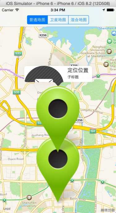
标签:
该博文在上一博文地图与定位之地图、大头针的基础上完成。
在MyAnnotation.h 中增加属性
#import <Foundation/Foundation.h>
#import <MapKit/MapKit.h>
//MKAnnotation是一个协议 ,添加大头针久需要实现该协议
//coordinate 属性是必须的,所以需要实现该属性
@interface MyAnnotation : NSObject<MKAnnotation>
@property(nonatomic,strong)UIImage *image;
-(id)initWithCoordinate:(CLLocationCoordinate2D)coordinate title:(NSString *)title subtitle:(NSString *)subtitle;
@end
在ViewController.m中
#import "ViewController.h"
#import <CoreLocation/CoreLocation.h>
#import <MapKit/MapKit.h>
#import "MyAnnotation.h"
@interface ViewController ()<CLLocationManagerDelegate,MKMapViewDelegate>
@property(nonatomic,strong)MKMapView *mapView;
@property(nonatomic,strong)CLLocationManager *locationManager;
@end

@implementation ViewController

- (void)viewDidLoad {
    [super viewDidLoad];
    _locationManager=[[CLLocationManager alloc]init];
    BOOL enable=[CLLocationManager locationServicesEnabled];
    NSLog(@"%d",[CLLocationManager authorizationStatus]);
    if (!enable) {
        NSLog(@"用户未开启定位服务,无法定位");
        return;
    }
    else if ([CLLocationManager authorizationStatus]<3)
    {
        [_locationManager requestWhenInUseAuthorization];
    }
    CLLocationDistance distance=10.0;
    _locationManager.distanceFilter=distance;
    _locationManager.delegate=self;
    _locationManager.desiredAccuracy=kCLLocationAccuracyBest;
    [_locationManager startUpdatingLocation];
    self.mapView=[[MKMapView alloc]initWithFrame:CGRectMake(0, 0, self.view.frame.size.width, self.view.frame.size.height)];

    //地图类型
//    typedef NS_ENUM(NSUInteger, MKMapType) {
//        MKMapTypeStandard = 0, //标准地图
//        MKMapTypeSatellite,   //卫星地图
//        MKMapTypeHybrid       //混合地图
//    }
    self.mapView.mapType=MKMapTypeStandard;
    //是否定位当前位置 否显示当前位置
    self.mapView.showsUserLocation=YES;
     //代理设置
    self.mapView.delegate=self;

//    typedef struct {
//        CLLocationCoordinate2D center;
//        MKCoordinateSpan span;
//    } MKCoordinateRegion;

    //中心点经纬度
    CLLocationCoordinate2D  locationCoordinate2D;
    locationCoordinate2D.latitude=22.544349;
    locationCoordinate2D.longitude= 113.94787;
    //范围比例尺
    MKCoordinateSpan coordinateSpan;
    //纬度
    coordinateSpan.latitudeDelta=0.05;
    //经度
    coordinateSpan.longitudeDelta=0.05;
    //设置显示区域
    MKCoordinateRegion coordinateRegion;
    coordinateRegion.center=locationCoordinate2D;
    coordinateRegion.span=coordinateSpan;
    [self.mapView setRegion:coordinateRegion animated:YES];
//    self.mapView.region=coordinateRegion;

//    typedef NS_ENUM(NSInteger, MKUserTrackingMode) {
//        MKUserTrackingModeNone = 0, // the user‘s location is not followed
//        MKUserTrackingModeFollow, // the map follows the user‘s location
//        MKUserTrackingModeFollowWithHeading, // the map follows the user‘s location and heading
//    }
    self.mapView.userTrackingMode=MKUserTrackingModeFollow;
    [self.view addSubview:self.mapView];

    UISegmentedControl *segmentedControl=[[UISegmentedControl alloc]initWithItems:@[@"普通地图",@"卫星地图",@"混合地图"]];
    segmentedControl.selectedSegmentIndex=0;
    [segmentedControl addTarget:self action:@selector(selectSegmentIndex:) forControlEvents:UIControlEventValueChanged];
    self.navigationItem.titleView=segmentedControl;

    //定义大头针类
    MyAnnotation *annotation=[[MyAnnotation alloc]initWithCoordinate:locationCoordinate2D title:@"主标题" subtitle:@"子标题"];
    annotation.image=[UIImage imageNamed:@"annotation.png"];
    [self.mapView addAnnotation:annotation];


}
-(void)locationManager:(CLLocationManager *)manager didUpdateLocations:(NSArray *)locations
{
    if (locations.count>0) {
        CLLocation *location=[locations firstObject];
        CLLocationCoordinate2D locationCoordinate2D =location.coordinate;
        [self.mapView setRegion:MKCoordinateRegionMake(locationCoordinate2D, self.mapView.region.span) animated:YES];

        NSLog(@"%lf ,%lf",locationCoordinate2D.longitude,locationCoordinate2D.longitude);

        MyAnnotation *annotation=[[MyAnnotation alloc]initWithCoordinate:locationCoordinate2D title:@"定位位置" subtitle:@"子标题"];
        annotation.image=[UIImage imageNamed:@"annotation.png"];
        [self.mapView addAnnotation:annotation];

    }
}
 //默认返回nil,采用服用的思想
//显示大头针时调用,注意方法中的annotation参数是即将显示的大头针对象
-(MKAnnotationView *)mapView:(MKMapView *)mapView viewForAnnotation:(id<MKAnnotation>)annotation
{
     //由于当前位置的标注也是一个大头针,所以此时需要判断,此代理方法返回nil使用默认大头针视图
    if ([annotation isKindOfClass:[MyAnnotation class]]) {
        static NSString *key=@"annotation";
        MKAnnotationView *annotationView=[self.mapView dequeueReusableAnnotationViewWithIdentifier:key];
        if (annotationView==nil) {
            annotationView=[[MKAnnotationView alloc]initWithAnnotation:annotation reuseIdentifier:key];
            //允许交互点击
            annotationView.canShowCallout=true;
            //定义详情视图偏移量
            annotationView.calloutOffset=CGPointMake(0, 1);
            //详情左视图
            annotationView.leftCalloutAccessoryView=[[UIImageView alloc]initWithImage:[UIImage imageNamed:@"email.png"]];

        }
        //修改大头针视图
        //重新设置此类大头针视图的大头针模型(因为有可能是从缓存池中取出来的,位置是放到缓存池时的位置)
        annotationView.annotation=annotation;
        //设置大头针图片
        annotationView.image=((MyAnnotation *)annotation).image;
        return annotationView;
    }
    else
    {
        return nil;
    }
}
//大头针选中
-(void)mapView:(MKMapView *)mapView didSelectAnnotationView:(MKAnnotationView *)view
{
    MyAnnotation *annotation=view.annotation;
    NSLog(@"%@",annotation.title);
}
//定位失败
-(void)locationManager:(CLLocationManager *)manager didFailWithError:(NSError *)error
{
    NSLog(@"定位失败");
    NSLog(@"%@",error);
}
- (void)selectSegmentIndex:(UISegmentedControl *)control
{
    NSInteger index = control.selectedSegmentIndex;

    /*
     MKMapTypeStandard  普通地图(标准地图),
     MKMapTypeSatellite 卫星地图,
     MKMapTypeHybrid    混合地图
     */

    MKMapType mapType;

    switch (index)
    {
            //普通地图
        case 0:
            mapType = MKMapTypeStandard;
            break;
            //卫星地图
        case 1:
            mapType = MKMapTypeSatellite;
            break;
            //普通和卫星的混合地图
        case 2:
            mapType = MKMapTypeHybrid;
            break;

        default:
            break;
    }

    //改变地图类型
    self.mapView.mapType = mapType;
}

- (void)didReceiveMemoryWarning {
    [super didReceiveMemoryWarning];
    // Dispose of any resources that can be recreated.
}

@end

标签:
原文地址:http://www.cnblogs.com/cuiyw/p/4441770.html