by Top Liu
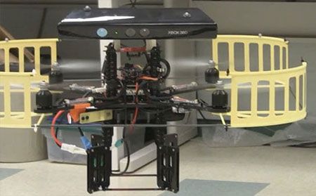
最近打算使用Kinect实现机器人的室内导航,收集了近年来的一些比较好的文章。
基于Kinect系统的场景建模与机器人自主导航
下载:http://robot.sia.cn/CN/article/downloadArticleFile.do?attachType=PDF&id=15382
国外文献:
1.Mobile Robots Navigation in Indoor Environments Using Kinect
This paper appears in:
Critical Embedded Systems (CBSEC), 2012 Second Brazilian
没了方便没有IEEE账户的朋友,我已上传到百度文库。下面的文章可直接点击下载
2.Using a Depth Camera for Indoor Robot Localization and Navigation
Abstract—Depth cameras are a rich source of information for
robot indoor localization and safe navigation. The recent availability
of the low-cost Kinect sensor provides a valid alternative
to other available sensors, namely laser-range finders. This
paper presents the first results of the application of a Kinect
sensor on a wheeled indoor service robot for elderly assistance.
The robot makes use of a metric map of the environment’s
walls and uses the depth information of the Kinect camera to
detect the walls and localize itself in the environment. In our
approach an error minimization method is used providing realtime
efficient robot pose estimation. Furthermore, the depth
camera provides information about the obstacles surrounding
the robot, allowing the application of path-finding algorithms
such as D* Lite achieving safe and robust navigation. Using
the proposed solution, we were able to adapt a robotic soccer
robot developed at the University of Aveiro to successfully
navigate in a domestic environment, across different rooms
without colliding with obstacles in the environment.
3.Depth Camera Based Indoor Mobile Robot Localization and Navigation
Abstract—The sheer volume of data generated by depth
cameras provides a challenge to process in real time, in
particular when used for indoor mobile robot localization and
navigation. We introduce the Fast Sampling Plane Filtering
(FSPF) algorithm to reduce the volume of the 3D point cloud
by sampling points from the depth image, and classifying local
grouped sets of points as belonging to planes in 3D (the “plane
filtered” points) or points that do not correspond to planes
within a specified error margin (the “outlier” points). We then
introduce a localization algorithm based on an observation
model that down-projects the plane filtered points on to 2D, and
assigns correspondences for each point to lines in the 2D map.
The full sampled point cloud (consisting of both plane filtered
as well as outlier points) is processed for obstacle avoidance
for autonomous navigation. All our algorithms process only
the depth information, and do not require additional RGB
data. The FSPF, localization and obstacle avoidance algorithms
run in real time at full camera frame rates (30Hz) with low
CPU requirements (16%). We provide experimental results
demonstrating the effectiveness of our approach for indoor
mobile robot localization and navigation. We further compare
the accuracy and robustness in localization using depth cameras
with FSPF vs. alternative approaches that simulate laser
rangefinder scans from the 3D data.
4.Using a Depth Camera for Indoor Robot Localization and Navigation
Abstract—Depth cameras are a rich source of information for
robot indoor localization and safe navigation. The recent availability
of the low-cost Kinect sensor provides a valid alternative
to other available sensors, namely laser-range finders. This
paper presents the first results of the application of a Kinect
sensor on a wheeled indoor service robot for elderly assistance.
The robot makes use of a metric map of the environment’s
walls and uses the depth information of the Kinect camera to
detect the walls and localize itself in the environment. In our
approach an error minimization method is used providing realtime
efficient robot pose estimation. Furthermore, the depth
camera provides information about the obstacles surrounding
the robot, allowing the application of path-finding algorithms
such as D* Lite achieving safe and robust navigation. Using
the proposed solution, we were able to adapt a robotic soccer
robot developed at the University of Aveiro to successfully
navigate in a domestic environment, across different rooms
without colliding with obstacles in the environment.
5.Using the Kinect as a Navigation Sensor for Mobile Robotics
ABSTRACT
Localisation and mapping are the key requirements in mobile
robotics to accomplish navigation. Frequently laser scanners
are used, but they are expensive and only provide 2D mapping
capabilities. In this paper we investigate the suitability
of the Xbox Kinect optical sensor for navigation and simultaneous
localisation and mapping. We present a prototype
which uses the Kinect to capture 3D point cloud data of the
external environment. The data is used in a 3D SLAM to
create 3D models of the environment and localise the robot
in the environment. By projecting the 3D point cloud into
a 2D plane, we then use the Kinect sensor data for a 2D
SLAM algorithm. We compare the performance of Kinectbased
2D and 3D SLAM algorithm with traditional solutions
and show that the use of the Kinect sensor is viable. However,
its smaller field of view and depth range and the higher
processing requirements for the resulting sensor data limit its
range of applications in practice.
Mobile Autonomous Robot using the Kinect
国外一个project

